Bull Lake Cabin in Troy, Montana

Six miles east of Troy on US Highway 2, a trail drops through the pines toward a sound you hear before you see it: the Kootenai River gathering itself and pouring over a shelf of ancient rock. The Forest Service calls Kootenai Falls one of the largest free flowing waterfalls in the northwest — the river drops 90 feet in less than a mile here, with the main falls standing 30 feet high. Just downstream, a narrow suspension bridge crosses the gorge.
Together they make one of the best short walks in this corner of Montana, and one of the easiest to fold into a day from a cabin on Bull Lake. This guide covers how to find the trailhead, what the walk is actually like, when to go, and a few things worth knowing before you set out.
A place to walk gently
Before the practicalities, one thing the Forest Service asks visitors to carry with them. The area around Kootenai Falls and the swinging bridge is culturally significant to the Kootenai Tribe of Idaho and the Confederated Salish and Kootenai Tribes, and they ask that people treat it as the special and sacred place it is. Stay on the trail, take your rubbish with you, and give the site the quiet it deserves. It costs nothing and it matters.
Where it is and how to get there
The parking area sits on the north side of US-2 at the 21 mile marker, 6 miles east of Troy and 12 miles west of Libby. Watch for the brown historical signs just before the pull-off — it comes up quickly at highway speed.
From Shangrilog the trailhead is 25.7 miles, about 31 minutes. That is a genuine half-day outing rather than an expedition: you can leave after a slow breakfast, walk the trail properly, and be back on the deck with the afternoon still ahead of you.
Because the lot sits right on the highway, you are on the trail within a minute of stepping out of the car. No forest road, no gate, no long approach.
The walk: trail, railroad crossing, and stairs
Short, and more varied than the distances suggest. The Forest Service puts the trail to the swinging bridge at roughly half a mile, with the falls overlook closer at about a third of a mile. Do both — together they are still a modest walk, and each gives you a different river.
The first 500 feet are fairly level and lead to an overlook with accessible access, where you can catch a glimpse of the falls or sit in the shaded picnic area maintained by Lincoln County Parks. If someone in your group is not up for the full walk, this is a real destination in itself rather than a consolation prize.
Beyond that overlook the trail turns to dirt and gets rough and rocky as it descends to an overpass across the railroad tracks. The overpass exits onto a three-tier metal staircase — 64 expanded metal steps. Sturdy shoes make a difference here, and this is the stretch to keep children close on.
The falls
The overlook trail winds through forest with benches and viewpoints before dropping toward the river. Upstream of the falls the water runs through China Rapids, then gathers speed and goes over the lip in a stair-step of rock slabs.
When the water is low you can pick your way among the exposed rock near the edge. When the river is running high in spring, stay well back. There is nothing between you and the full weight of the Kootenai here, and the current is not something to test.
The swinging bridge
The suspension bridge is why many people make the trip. It crosses the gorge downstream of the falls, high above green water threading between rock walls, and it moves under you as you walk — gently, which is part of the fun if you are comfortable with heights and a little unnerving if you are not. Either way the views up and down the river are worth the crossing. The far side has a few primitive, unmaintained trails; most visitors take in the view and turn back.
A little history underfoot
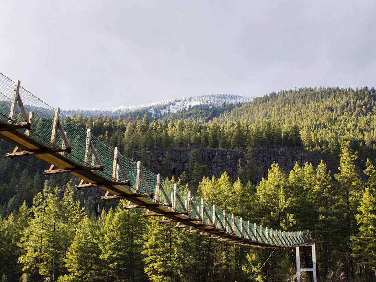
The first bridge here was built by the Civilian Conservation Corps in 1937, to improve access for firefighting on the far side of the river. Flooding destroyed it in 1948. It was rebuilt on concrete towers in the 1950s, reconstructed on the existing cables and supports in 1993, and in 2018 the Forest Service determined that further reconstruction was needed to improve public safety.
The rock beneath your feet is older by an almost silly margin. The falls are cut through quartzite and limestone of the Belt Supergroup — rock around 1.5 billion years old, carrying preserved mud chips, salt casts and ripple marks from an ancient shallow sea. Slight folds in that underlying geology are what give the falls their stair-step shape. Look for fossilised algal mounds called stromatolites near the newer bridge, and for folded rock layers north of the river and in the road cut along Highway 2.
In the early 1800s the explorer David Thompson came through this country using the Kootenai as a navigational guide, and portaged around the falls on a trail 300 feet above the river. His journal is blunt about what a slip would have meant. Standing at the overlook, you can see his point.
When to visit
Any time you are passing, honestly — but the seasons each give you a different place.
Late spring
Late May into mid-June is peak runoff and the most thunderous water. It is also when caution near the edge matters most, and when the spray will find your camera lens.
Summer
The busiest season, and the most reliable weather. The concession is open and the picnic area gets used. Expect company on the bridge; early morning or the last hour of light will give you a quieter walk.
Fall
Crisp air, thinner crowds, and larch turning gold on the slopes above the river. If you only get one visit, this is the one to aim for.
Winter
The falls can ice into something extraordinary and you may well have the place to yourself, but the metal stairs and the rocky section get genuinely slick, and highway conditions vary. Check the Forest Service’s current conditions and alerts before you set out, and be willing to turn around.
Know before you go
A short list, and the first two are the ones that catch people out.
Leave the dog at home. The Forest Service states plainly that the railroad overpass and the metal staircase are not dog friendly — 64 expanded metal steps are hard on paws and difficult to carry a dog down safely. This is not a leash-and-manage situation; it is a trail that is genuinely unsuitable for dogs past the first overlook.
The water has no barriers. There is nothing between the trail and the river near the falls. Keep a firm hold on children and give the water a wide margin, particularly during high flow.
Wear real shoes. Rocky, root-crossed trail and 64 metal steps. Trainers will do; flip-flops will not.
Facilities are at the trailhead, not on the trail. Lincoln County Parks maintains the picnic area just off the parking lot, with tables, barbecue areas and restrooms. A concession service operates at the falls parking lot from May through September with food, souvenirs and visitor information. Outside those months, bring what you need.
Wildlife lives here. Bighorn sheep, elk and black bears all use this country. Seeing them is a possibility, not a promise — keep your distance and store food sensibly either way.