Bull Lake Cabin in Troy, Montana

Most travelers who visit Kootenai Falls arrive by accident.
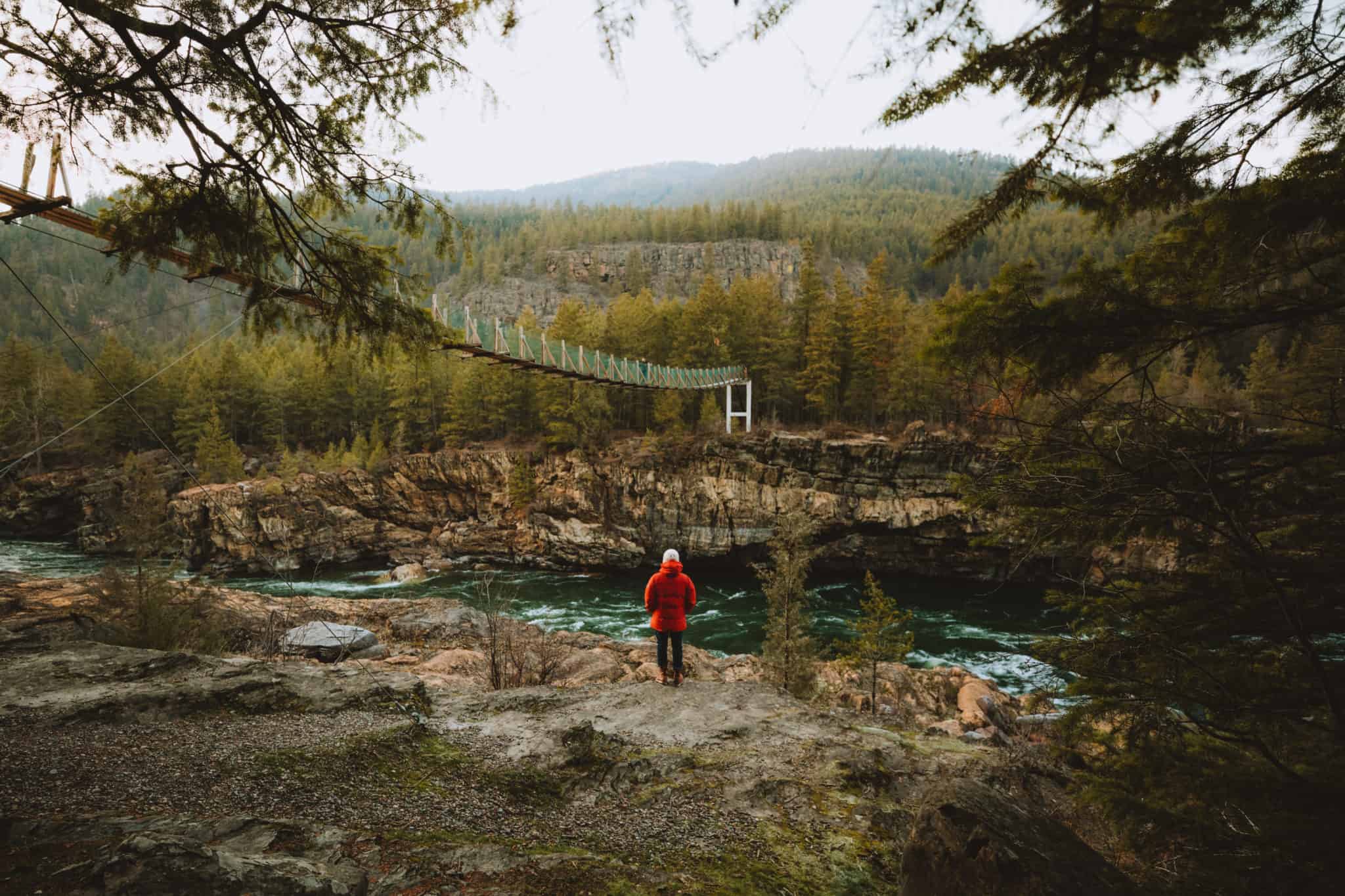
They’re driving Highway 2 between Libby and Troy — headed to Glacier, or coming from Idaho, or simply passing through the northwest corner of Montana on their way somewhere else. They see the brown Forest Service sign, pull over on impulse, walk the 1.2-mile trail through old-growth ponderosa pine, and arrive at a 90-foot waterfall dropping through a basalt canyon with a swinging footbridge spanning the gorge downstream.
They spend an hour. They get back in the car. They drive away thinking about it for the rest of the trip.
What they didn’t know when they pulled off the highway is that the falls are the organizing feature of one of the most complete outdoor destination experiences in Northwest Montana — that the waterfall, the canyon, the river, the surrounding Kootenai National Forest, the ancient cedar groves 10 miles south, and the pristine mountain lake 20 minutes north together constitute a destination worth building a trip around rather than stopping at for an hour.
This guide is for travelers who have decided — before or after that accidental first visit — to plan a trip around Kootenai Falls. It covers every lodging option in the area, what each delivers relative to the falls and the surrounding corridor, and why Bull Lake is the most rewarding basecamp for experiencing everything Kootenai Falls and its surrounding region has to offer.
For the complete overview of Montana fishing and hiking cabin options across Northwest Montana, see the Montana Fishing & Hiking Cabins guide →
Understanding Kootenai Falls
What Makes the Falls Significant
Kootenai Falls is Montana’s largest undammed waterfall by volume — a distinction that matters because it reflects what the Kootenai River actually does at this location. The river drops through a series of basalt ledges over approximately a quarter mile, culminating in a primary drop of roughly 90 feet before funneling through a narrow canyon where the swinging bridge crosses.
The volume is the defining characteristic. Unlike many “waterfall” attractions in the American West that are impressive primarily during spring snowmelt and become modest trickles by August, the Kootenai Falls runs at substantial volume year-round — fed by Libby Dam’s regulated releases upstream, which maintain relatively consistent river flows regardless of season or precipitation. This is a waterfall that is genuinely impressive on any day of any month.
The canyon the river carved through the basalt is a secondary attraction in its own right — dark, ancient rock formations visible at the viewing platform and from the swinging bridge, with the river visible dropping through the gorge below the bridge in a way that produces a specific kind of vertigo in visitors who walk to the bridge’s center.
Cultural Significance
Kootenai Falls holds deep spiritual significance to the Kootenai Tribe, who have lived in this valley for thousands of years and consider the falls a sacred site. The interpretive signage along the trail acknowledges this history — a dimension of the experience that most visitors read carefully and leave with a deeper sense of what makes this particular waterfall different from a purely scenic resource.
The falls also appeared as a filming location in the 2015 film The Revenant — a detail that surprises visitors who recognize the canyon setting and adds a layer of cinematic familiarity to the landscape.
The Swinging Bridge
The swinging footbridge spanning the Kootenai River downstream from the falls is, for many visitors, the most memorable physical experience of the entire site. It hangs approximately 90 feet above the river, sways with any weight distribution change, and provides a view down the canyon that is simultaneously spectacular and viscerally uncomfortable for visitors with any sensitivity to heights.
Crossing the bridge is not required — the viewpoint above the falls is the primary attraction and is accessible without the bridge crossing. For visitors who do cross it, the downstream canyon view from the bridge’s center is a perspective on the river that photographs rarely capture adequately.
Access and Logistics
Location: Highway 2, approximately 10 miles west of Libby and 15–20 minutes east of Troy. The parking area is clearly signed on the south side of the highway.
Trail: 1.2 miles roundtrip from the parking area to the viewpoint and bridge. Paved and well-maintained for the first section; natural surface trail for the final approach to the viewpoint. Accessible to most fitness levels and appropriate for families with children capable of a 1-mile walk.
Admission: Free. No reservation required. No entrance fee.
Season: Accessible year-round when Highway 2 is clear. The falls are visually impressive in every season — ice formations on the basalt ledges in winter, peak snowmelt volume in May–June, and clear low-water views of the basalt geology in late summer and fall.
Parking: Standard highway pullout with parking for approximately 20–30 vehicles. Can fill on summer weekends but rarely produces the parking problems that national park attractions create.
The Kootenai Falls Corridor: What’s Around It
Understanding Kootenai Falls as the center of a broader experience — rather than a standalone stopping point — changes how you plan lodging around it.
West on Highway 2 — Troy and Bull Lake (15–20 minutes)
Troy sits 15–20 minutes west of Kootenai Falls on Highway 2 — a small working town at the confluence of the Bull and Kootenai Rivers with basic services, an authentic small-town Montana character, and access to the Bull Lake corridor via Highway 56 north.
From Troy, Bull Lake is 20 minutes north on Highway 56 — the premier lodging destination for travelers who want Kootenai Falls access combined with lakefront living, wilderness hiking access, and the broadest range of Northwest Montana experiences from one basecamp.
The Bull Lake positioning for Kootenai Falls visitors: Most travelers who make Kootenai Falls the organizing feature of their trip discover that the falls are best experienced multiple times — morning light, evening light, different water levels, different seasons. A Bull Lake basecamp that puts the falls 35 minutes away enables multiple visits across a multi-night stay rather than a single rushed experience.
East on Highway 2 — Libby (10–15 minutes)
Libby sits 10–15 minutes east of Kootenai Falls — the full-service community that provides everything the falls area itself lacks: full grocery, hardware, medical facilities, the widest dining selection in Lincoln County, and access to the Libby Ranger District Forest Service office for current conditions and trail information.
For travelers who want Kootenai Falls access combined with the most complete service infrastructure in Lincoln County, a Libby-area cabin positions you equally close to the falls with the county’s best services immediately available.
For Libby-area lodging specifically, see Libby Montana Cabin Rentals →
South on Highway 56 — Ross Creek Cedars (10 miles from Troy)
Ross Creek Cedars sits approximately 10 miles south of Troy on Highway 56 — 30–40 minutes from Kootenai Falls via Highway 2 and Highway 56. The ancient cedar grove and the falls are the two most distinctive natural attractions in the Lincoln County corridor, and most visitors who find one are eventually told about the other.
The logical itinerary for a Kootenai Falls-area trip includes both — morning at the falls, afternoon at the cedars (or vice versa) — producing a single day that covers the two most memorable outdoor experiences the region offers outside of wilderness hiking.
For lodging specifically near Ross Creek Cedars, see Ross Creek Cedars Area Lodging →
North on Highway 56 — Cabinet Mountains Wilderness Trailheads (20–45 minutes from Troy)
The western approach to the Cabinet Mountains Wilderness — including the Scotchman Peak trailhead — is accessible from the Highway 56 corridor north and south of Troy, typically 20–45 minutes from most Kootenai Falls area lodging.
For travelers who want Kootenai Falls access combined with Cabinet Mountains wilderness hiking, the Bull Lake basecamp covers both without compromise. For a complete guide to Cabinet Mountains wilderness cabin access, see Cabinet Mountains Wilderness Rentals →
Kootenai Falls Area Lodging Options
Bull Lake Lakefront Cabins — The Premier Option
For travelers planning an extended stay (3+ nights) in the Kootenai Falls area, Bull Lake lakefront properties represent the strongest overall lodging option — combining falls access with lakefront living, wilderness hiking proximity, and the kind of space and amenities that make a multi-night stay genuinely comfortable.
Shangrilog on Bull Lake is the standout property: a 3,000-square-foot handcrafted log home on 85 feet of private shoreline with a private dock, four bedrooms sleeping 10, a wood-burning fireplace, a hot tub on the deck, and year-round availability. Kootenai Falls is 35 minutes east on Highway 2 — close enough for an evening visit, a morning visit, or a return visit on consecutive days of a multi-night stay.
The Bull Lake position relative to Kootenai Falls delivers something that Libby-area lodging cannot: the falls as a daily-accessible feature of the stay rather than the primary reason to be there. Travelers based at Bull Lake visit Kootenai Falls the way people with lakeside homes visit the local waterfall — frequently, casually, and at their preferred time of day. Travelers staying in Libby visit the falls the way tourists visit an attraction — once, carefully, before moving on.
Distance from Shangrilog to Kootenai Falls: 35 minutes east on Highway 2. Peak season rates: $175–$350 per night. Best for: Groups of 4–10, extended stays, travelers who want falls access as part of a broader Northwest Montana experience.
Troy Area Cabin Rentals — Closest Access
Troy sits 15–20 minutes from Kootenai Falls — the closest community to the falls with a vacation rental market. For travelers whose primary reason for visiting is specifically Kootenai Falls, Troy-area cabin rentals provide the shortest drive to the site.
The Troy rental market covers a range of property types — riverfront cabins along the Kootenai, Bull Lake-adjacent properties via Highway 56 north, and in-town or near-town options for travelers who need service proximity. Basic services in Troy — grocery, gas — are available for day-to-day needs; Libby (30 minutes east) handles full resupply.
For the complete Troy area lodging guide, see Troy MT Vacation Rentals →
Distance from Troy to Kootenai Falls: 15–20 minutes east on Highway 2. Peak season rates: $125–$300 per night for most Troy-area rentals. Best for: Short stays (1–2 nights) specifically focused on Kootenai Falls. Travelers who want maximum falls proximity as the primary criterion.
Kootenai River Corridor Cabins — Falls and River Combined
Riverfront cabin properties along the Kootenai between Troy and Libby sit within the corridor that includes the falls — some as close as 5–10 minutes from the parking area, others 20–25 minutes in either direction.
For anglers who want to combine Kootenai Falls visits with Gold Medal tailwater fishing, a Kootenai River corridor cabin covers both without driving between activity zones. The river that drops through the falls is the same river that produces the world-class rainbow trout fishing immediately above and below — staying on the river connects both experiences.
For complete Kootenai River corridor lodging, see Kootenai River Lodge Stays →
Distance from Kootenai River corridor to falls: 5–25 minutes depending on specific property location. Peak season rates: $150–$325 per night. Best for: Anglers who want falls access and river fishing from the same property. Road trippers who want to spend time along the corridor rather than basing at a lake.
Libby Area Accommodations — Service-First Option
Libby’s hotels and cabin rentals put travelers 10–15 minutes from Kootenai Falls with the best service infrastructure in Lincoln County immediately available. For travelers who need full grocery access, reliable dining options, or the comfort of knowing a hospital is close, Libby-area lodging is the practical choice.
The trade-off is character — Libby is a functional small city, not a wilderness basecamp. Travelers who specifically want the lakefront or riverfront immersion that distinguishes the best Kootenai Falls area lodging from adequate accommodations will find Libby less compelling than Bull Lake or Troy-area properties.
For Libby-area lodging in full detail, see Libby Montana Cabin Rentals →
Distance from Libby to Kootenai Falls: 10–15 minutes west on Highway 2. Peak season rates: $125–$325 per night for vacation rentals; $80–$180 for hotels. Best for: Travelers who prioritize service access. Short stays using Libby as a Highway 2 corridor base.
Forest Service Cabins — Remote Immersion
The Kootenai National Forest operates historic cabin rentals through Recreation.gov in the Libby and Troy ranger districts — rustic properties at $50–$100 per night that put travelers in genuine national forest settings within the broader Kootenai Falls corridor.
These properties require comfort with rustic conditions — wood stoves, basic plumbing, no electricity in most cases. For travelers who want maximum immersion in the Kootenai National Forest landscape while maintaining access to Kootenai Falls and the Highway 2 corridor, Forest Service cabins are the most affordable option with the most authentic character.
For the complete Kootenai National Forest cabin guide, see Kootenai National Forest Cabins →
Planning a Kootenai Falls Area Trip
The Ideal Itinerary: 4 Nights from Bull Lake
The most complete Kootenai Falls area experience unfolds over 4–5 nights from a Bull Lake basecamp — enough time to visit the falls at different times and in different light, explore the surrounding corridor attractions, and balance active days with lakefront recovery.
Day 1: Arrive at Bull Lake. Evening visit to Kootenai Falls (35 minutes east) — late afternoon light on the basalt canyon is exceptional. Dinner at the cabin.
Day 2: Scotchman Peak full day — leave at 7 AM from the cabin, summit by midday, return by late afternoon. Hot tub and dinner at the cabin.
Day 3: Ross Creek Cedars morning — 30–40 minutes south on Highway 56, 2 hours in the cedar grove. Return to Bull Lake for afternoon dock fishing and kayaking.
Day 4: Kootenai Falls second visit — morning light this time, and cross the swinging bridge if you didn’t on Day 1. Afternoon Kootenai River fishing or Libby resupply run. Evening fire at the cabin.
Day 5: Explore the Bull River corridor, rest day at the lake, or optional Glacier National Park day trip (2.5 hours east). Evening departure or final lake morning.
This itinerary covers the falls twice in different light conditions — the way a destination deserves to be visited rather than checked off a list.
Best Times to Visit Kootenai Falls
Spring (April–June): Peak Volume Spring snowmelt brings the Kootenai River to its highest volume of the year — April through June produces the most dramatic falls display, with the full force of the river visible in the canyon. The trail can be muddy in early spring; waterproof footwear is recommended. The surrounding ponderosa pine forest and the wildflower displays along the trail are at their most vivid in late May and June.
Summer (July–August): Visitor Peak The falls remain impressive year-round due to Libby Dam’s regulated releases — summer flow is lower than spring but still substantial. The trail is at its best condition. Families with young children find summer the most practical visiting window. Parking fills on busy summer weekends; arrive before 9 AM or after 4 PM to avoid the midday crowd.
Fall (September–October): The Best Window Fall combines the falls with the broader corridor at its most spectacular — western larch turning gold across the Kootenai National Forest, the river running clear and cold, and minimal visitor traffic compared to summer. The falls themselves are less dramatic than spring peak volume but the surrounding landscape is at its most beautiful. Morning light on the basalt canyon in October is exceptional.
Winter (November–March): Solitude and Ice Winter visits require appropriate footwear (icy conditions on the trail are possible) but reward visitors with ice formations on the basalt ledges and complete solitude — no other visitors on most winter days. The falls run at moderate volume maintained by dam releases. A winter visit to Kootenai Falls is one of the least-known and most memorable experiences in the Lincoln County corridor.
Photography at Kootenai Falls
Kootenai Falls is one of the most photographable natural sites in Northwest Montana — and one of the most technically challenging to capture well.
The primary falls: Best captured from the main viewpoint platform above the canyon. A wide-angle lens captures the full drop and the basalt canyon walls. Midday sun creates harsh shadows in the canyon; morning and evening light are significantly better.
The swinging bridge: Shot from the bridge itself or from the trail above the bridge. The bridge sways during exposure, so a fast shutter speed (1/250 or faster) is necessary for sharp images from the bridge deck. The downstream canyon view from the center of the bridge is the most dramatic perspective.
The river from above: The trail above the falls provides elevated perspectives on the river before the drop — a different visual character than the falls viewpoint itself, and less photographed.
Early morning: The best available light for the falls is typically 30–60 minutes after sunrise on clear mornings in summer and fall. The canyon orientation means midday light falls flat into the gorge.
Kootenai Falls and the Full Corridor Experience
The most important reframe for travelers planning a Kootenai Falls trip: the falls are not the only reason to be in this corridor. They are the organizing feature of a region that contains multiple extraordinary natural experiences within a 45-minute drive of each other.
Kootenai Falls (the centerpiece): 90-foot waterfall, basalt canyon, swinging bridge. Free, accessible, year-round.
Ross Creek Cedars (30 minutes south of Troy): 1,000-year-old western red cedars on a one-mile boardwalk. Free, accessible, late May–October.
Cabinet Mountains Wilderness (30–45 minutes from Troy): 94,272 acres of roadless backcountry. Scotchman Peak, Engle Lake, mountain goats, grizzly bear habitat. No permit required.
Bull Lake (20 minutes north of Troy): Pristine mountain lake within the Kootenai National Forest. Private dock fishing, kayaking, swimming, lakefront living. The most complete basecamp in the corridor.
Kootenai River tailwater (between Troy and Libby): Gold Medal wild rainbow trout fishery below Libby Dam. One of the best fly fishing rivers in Northwest Montana.
Libby Dam and Lake Koocanusa (35 minutes east of Troy): One of the largest dams in the Pacific Northwest, with an impressive overlook and visitor center. Lake Koocanusa — 90 miles of reservoir — accessible 25–30 minutes north of Libby for fishing and water recreation.
Travelers who plan a 4–5 night stay based at Bull Lake can cover all of these experiences without a single overnight relocation — the waterfall, the ancient cedars, the wilderness, the lake, and the river all within a morning’s drive of the same cabin.
Frequently Asked Questions
How far is Kootenai Falls from the nearest lodging?
The nearest lodging to Kootenai Falls is in the Troy area, approximately 15–20 minutes west on Highway 2. Libby-area lodging is 10–15 minutes east. Bull Lake properties are approximately 35 minutes via Highway 2 west and Highway 56 north. The falls sit midway between Libby and Troy — all Lincoln County lodging is within 35 minutes.
Is Kootenai Falls accessible year-round?
Yes, when Highway 2 is clear. The falls themselves run at substantial volume year-round due to Libby Dam’s regulated releases — they are not a seasonal attraction. The trail is accessible in all seasons with appropriate footwear; icy conditions in winter require microspikes or traction devices. The swinging bridge is open year-round.
What is the best lodging for seeing Kootenai Falls multiple times?
Bull Lake properties — specifically Shangrilog — put the falls close enough (35 minutes) for multiple visits across a 4–5 night stay without it feeling like a significant excursion. For travelers who want to experience the falls at different times of day and in different light conditions, a multi-night Bull Lake stay is the right approach.
Can I combine Kootenai Falls with other Northwest Montana attractions?
Yes — Kootenai Falls sits at the center of a corridor that includes Ross Creek Cedars (30–40 minutes south of Troy), the Cabinet Mountains Wilderness (30–45 minutes from Troy), Bull Lake (20 minutes north of Troy), and the Kootenai River Gold Medal fishery (the river the falls are on). A 4–5 night Bull Lake stay covers all of these from one basecamp. For the complete regional attractions overview, see the Kootenai National Forest Cabins guide →
Is the swinging bridge at Kootenai Falls safe?
Yes — the bridge is a maintained Forest Service structure in regular use. It swings noticeably with foot traffic, which some visitors find exhilarating and others find uncomfortable. Visitors with significant fear of heights or vertigo may find the bridge crossing distressing; the falls viewpoint is fully rewarding without crossing the bridge, and crossing is not required.
What time of year is Kootenai Falls most impressive?
Spring (April–June) produces the highest water volume and most dramatic falls display during snowmelt runoff. Fall (September–October) offers the best overall experience — impressive falls combined with western larch color, clear water, and minimal crowds. Winter offers unique ice formations and complete solitude. Summer is the most visitor-friendly season for families.
What else is near Kootenai Falls worth visiting?
Ross Creek Cedars (ancient cedar grove, 30 minutes south of Troy), Scotchman Peak in the Cabinet Mountains Wilderness (35–45 minutes from Troy), Bull Lake (20 minutes north of Troy), and the Kootenai River tailwater fishing between Troy and Libby. The falls are the most accessible entry point to a region with exceptional depth.
Is there camping near Kootenai Falls?
No dedicated campground sits immediately at the falls. The Kootenai National Forest maintains several campgrounds within the broader corridor — Bad Medicine Campground on Bull Lake and several sites in the Libby Ranger District are the closest established options. Forest Service cabin rentals through Recreation.gov provide the most immersive overnight experience in the national forest setting.
Plan Your Kootenai Falls Area Lodging
Kootenai Falls rewards travelers who stay — who visit it more than once, in different light, at different times of year, as part of a broader experience of the Lincoln County corridor rather than as a stop on the way to somewhere else.
The lodging that enables that relationship with the falls — close enough for casual repeat visits, positioned within the full corridor of Northwest Montana’s most compelling natural experiences, equipped for a multi-night stay with groups — is Shangrilog on Bull Lake.
For the complete Troy area lodging guide covering all property types and locations nearest the falls, see Troy MT Vacation Rentals →
For Libby-area lodging with full services 10–15 minutes east of the falls, see Libby Montana Cabin Rentals →
For the complete Kootenai National Forest lodging overview covering every cabin type in the region, see Kootenai National Forest Cabins →
Shangrilog on Bull Lake: 35 minutes from Kootenai Falls, 3,000 square feet sleeping 10, private dock, hot tub, year-round availability.