Bull Lake Cabin in Troy, Montana
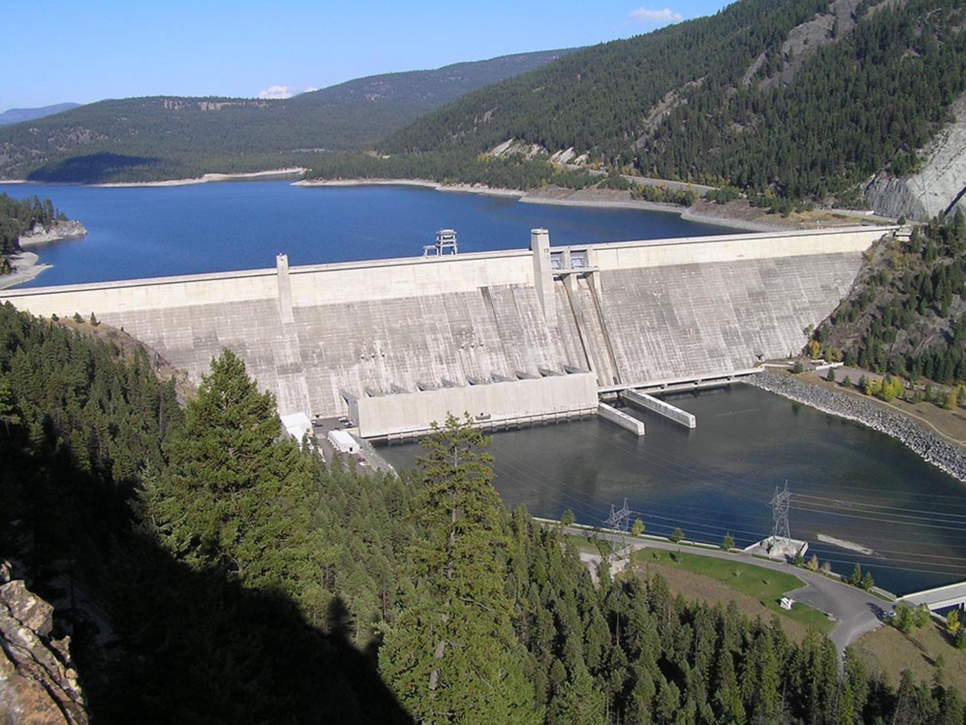
Libby Dam stands 17 miles upstream of Libby on the Kootenai River, just over an hour from Shangrilog by road. It is free to visit. The Visitor Center runs through the summer, free guided tours go out most days in June, July, and August, and there is a picnic area at the top with one of the better views in Lincoln County. Behind the dam, Lake Koocanusa reaches ninety miles north and crosses into British Columbia. Below it, the Kootenai runs cold and green toward Kootenai Falls. You can take in the whole story in an afternoon and still be back at the cabin before the light goes off the water.
From the cabin, head north on Highway 56 to US Highway 2, then east through Troy and on to Libby. In Libby, turn north onto Montana Highway 37 and drive 13.5 miles. Turn left onto Forest Road 228, follow it 3.5 miles, then turn right onto Souse Gulch Road. The Visitor Center sits at 260 Souse Gulch Road, on the west side at the top of the dam. The whole drive runs about 54 miles and takes a little over an hour.
Two practical notes before you go. Libby is your last reliable stop for fuel, groceries, and coffee, so fill up there. And cell coverage around the dam and Lake Koocanusa ranges from thin to nonexistent, so download your directions at the cabin rather than counting on a signal partway up Highway 37.
One more thing worth knowing: the roadway across the top of the dam is closed. If you approach from the north, coming south from the Eureka area on Highway 37, you take a scenic detour below the dam and cross the David Thompson Bridge to reach the other side. Coming up from Libby, as you will be, this does not affect you.
The Visitor Center is free and worth an hour on its own. There are two short films in a small theater, wildlife exhibits, hydropower displays, and a good stretch of regional history covering what the valley looked like before the water came up. There are clean restrooms and a small gift shop, which matters more than it sounds like on a day with kids.
For 2026, the Visitor Center is open from May 22 through September 7. Summer tours run in June, July, and August on this schedule: Monday through Saturday, a top-of-dam tour at 10 a.m. and 4 p.m.; Sunday, a powerhouse tour at 10 a.m., noon, 2 p.m., and 4 p.m. The powerhouse tour is the one that takes you inside.
The tour rules are firm, and it is better to know them at the cabin than at the gate. Everyone over 18 needs photo identification. Children must be accompanied by an adult. No phones and no backpacks are allowed on the tour. No pets. Some tours require hardhats and ear protection, which are provided, and closed-toe shoes are recommended.
That no-phones rule catches people out, so take your photographs from the overlook before the tour starts. And call ahead. Tours can be cancelled for construction activity or weather, and the Corps recommends checking the same day. The Visitor Center number is (406) 293-5577, and current details are posted on the U.S. Army Corps of Engineers Libby Dam recreation page.
The Souse Gulch day-use area sits right beside the Visitor Center and is where most families end up spending the rest of the afternoon. There are playgrounds, picnic shelters, corn hole boards, basketball hoops, and a boat ramp onto Lake Koocanusa. There is also the Kooky-Noosa disc golf course, eighteen holes laid out across the hillside, and it is genuinely challenging terrain rather than a flat park course.
Worth knowing if you are travelling with a range of ages: this is the spot that makes the trip work for everyone. The dam tour is not especially interesting to a six-year-old, but the playground and a picnic table with a ninety-mile reservoir in front of it usually are. Adults can take turns on the tour while the rest of the party stays put, which is easier here than at most attractions in the county.
Three of the shelters can be reserved in advance through Recreation.gov if you are bringing a crowd. If you are not, there is usually room to spread out a lunch with the lake in front of you. One thing to keep in mind: the back loop gate at Souse Gulch closes at dusk and reopens around 8 a.m., so plan your exit rather than discovering the gate on your way out.

Standing at the rail, the numbers help. Libby Dam is a concrete gravity dam, 422 feet tall and 3,055 feet long, which is better than half a mile across the valley. Its powerhouse holds five turbines with a capacity of 600 megawatts. It was authorized under the 1950 Flood Control Act, construction began in 1966, the structure was completed in 1972, and it was formally dedicated by President Gerald Ford on August 24, 1975.
Behind it, Lake Koocanusa runs about ninety miles upstream with a maximum depth near 370 feet. Forty-two of those miles are in British Columbia. The name is a portmanteau chosen through a public contest in 1971, stitched together from Kootenai, Canada, and USA, which is the kind of detail the tour guides enjoy delivering.
The river itself is the third largest tributary of the Columbia, contributing close to twenty percent of the water in the lower Columbia. And the dam has a selective withdrawal system, meaning operators can draw water from different depths of the reservoir to control the temperature of what goes downstream. That single piece of engineering is a large part of why the tailwater below the dam fishes the way it does.
The short answer is the flood of 1948, which tore through the Columbia basin and displaced thousands of people downstream. Flood control on the Kootenai went from a proposal to a priority, and Libby Dam was authorized two years later. The international piece took longer. Because the river rises in Canada and the reservoir would back up across the border, the project needed an agreement between two countries, and it became one of the dams built under the Columbia River Treaty.
What that meant on the ground was a decade of upheaval in the middle of Lincoln County. Filling the reservoir put the town of Rexford underwater, so the town was moved. The Great Northern Railway line had to be relocated. On the Canadian side, the community of Waldo, British Columbia, is now beneath the lake. Jennings Canyon, which had been a genuine obstacle to river travel for as long as anyone had tried it, simply disappeared under the water.
It is worth carrying that with you onto the overlook. The view is undeniably beautiful, and it is also entirely manufactured, ninety miles of engineered water sitting where a river valley and two towns used to be. The Visitor Center exhibits handle this honestly, with photographs of what the valley looked like before 1972, and they are the most interesting thing in the building.
Call us at (406) 295-0100 and we'll help you find the right dates for your stay at Shangrilog.
If the top of the dam is the postcard, the bottom is where you linger. The Downstream Recreation Area offers the classic upward view of the dam wall, a boat launch, a second eighteen-hole disc golf course, and a rails-to-trails hiking path built on an old railroad grade. That grade connects the Dunn Creek Flats area to the downstream launching area and the wildlife ponds, and it is designated foot traffic only to protect nesting wildlife.
There are four primitive campgrounds around the dam: Alexander Creek, Blackwell Flats, Downstream, and Dunn Creek Flats. They are first-come with a 14-day maximum stay and no reservations, marked out with fire rings and picnic tables. You are not camping, of course, but they are useful landmarks for finding the boat ramps and the quieter stretches of shoreline. If you would rather be on the water than beside it, our guide to kayaking the Kootenai River covers the paddling side of this corridor.
The corridor below the dam is a designated watchable wildlife area, and bald eagles and osprey are a regular presence here. There is a reason for it. Kokanee salmon from Lake Koocanusa pass through the turbines and arrive in the tailrace stunned or killed, which concentrates easy food in a small stretch of water, which in turn concentrates the birds that want it.
None of this is a guarantee, and any morning can come up empty. Bring binoculars, go early, and give it time. Dunn Creek Flats is a good place to sit quietly with a thermos and see what turns up. If birding is the point of your trip rather than a bonus, our guide to birdwatching in the Kootenai is a better starting place than this one.
The Kootenai below Libby Dam is a serious blue-ribbon tailwater, and the numbers back it up. The Montana state record rainbow trout, 33.1 pounds and 38.62 inches, was caught on August 1, 1997, at the David Thompson Bridge just below the dam.
It is also one of the more tightly regulated stretches of water in the state, and the rules are specific enough that visiting anglers get caught out. From Libby Dam down to the Highway 37 bridge near the Fisher River, only single-pointed hooks are permitted, and that section is open from June 1 through February 28. Rainbow trout are limited to one daily with a 28-inch minimum. Bull trout are catch-and-release and must be released immediately. And every brown trout caught between Libby Dam and Kootenai Falls must be killed, kept, and turned in to Montana Fish, Wildlife and Parks, which is an invasive-control measure rather than a typo.
Regulations here change between seasons, so check the current Montana FWP fishing regulations before you fish rather than relying on a guide written last year, including this one. If fishing is the reason for your trip, we have written about fishing Bull Lake in more depth, and it is a five-minute walk from the door rather than an hour’s drive.
Flows below a working dam are not weather-driven, and they do not announce themselves. When generation increases, the river comes up, and it comes up quickly, cold, and stronger than it looks from the bank.
It helps to know what drives those changes, because they are not random. Every spring, the Corps runs what is called sturgeon flow augmentation, releasing water at close to full powerhouse capacity, roughly 25,000 cubic feet per second, for a few weeks to create spawning conditions for the endangered Kootenai River white sturgeon downstream near Bonners Ferry, Idaho. The timing shifts each year with the runoff forecast, but it usually lands in the second half of May. Once that operation finishes, outflows step back down to a stable summer level, held above a minimum set to protect bull trout.
The practical version for a visitor: in late May and early June the river below the dam is high, fast, and loud, and it is a spectacular thing to look at from a safe distance. At any time of year, stay off gravel bars you would have to wade back from, keep children where you can reach them, and treat a rising edge as a signal to move rather than something to watch. On the reservoir side, wear the life jacket. The lake is deep and the water stays cold well into summer.
The most satisfying version of this trip follows the river. Libby Dam sits upstream of Libby; Kootenai Falls and the swinging bridge sit downstream, west along US Highway 2 toward Troy. Doing both in a day means seeing the same water controlled and then set loose, which is a better half-hour of perspective than either stop delivers alone. The falls are closer to the cabin, so it works well to take the dam in the morning and stop at the falls on the way home.
A summer day that works, if you want one already sequenced:
If the weather turns, Ross Creek Cedars is the better call. The grove holds up in rain in a way that an exposed dam overlook does not, and it is a much shorter drive from Bull Lake. Either way, most people find they want the afternoon back at the cabin, on the dock, with nothing else scheduled. There is more in our full guide to exploring the Bull Lake area.
Summer is the only season with full access. Tours run in June, July, and August, and the Visitor Center is open seven days a week through September 7 in 2026. If a dam tour is on your list, that window is the whole answer.
Late spring has its own argument. The sturgeon release usually falls in the back half of May, and a river running at full powerhouse capacity is worth seeing even if the Visitor Center has only just opened for the season.
Fall is the better drive. Highway 37 along the lower reservoir turns gold as the larch go, usually somewhere in the back half of October, and the crowds thin considerably. The Visitor Center closes after the summer season, so a fall trip is a scenic drive, an overlook, and the downstream area rather than a tour.
In winter and spring, the grounds and the downstream recreation area are still worth the drive if the roads are clear, and the Visitor Center operates by appointment. Construction activity at the site has affected access in recent seasons, so calling (406) 293-5577 first is not optional in the shoulder months.
Libby Dam is about 54 miles from Shangrilog, a little over an hour by road. The route runs north on Highway 56 to US Highway 2, east through Libby, then north on Montana Highway 37 for 13.5 miles before turning onto Forest Road 228.
No. The Visitor Center, the guided dam tours, and the Souse Gulch day-use area are all free to the public. The dam is operated by the U.S. Army Corps of Engineers.
The Visitor Center is open May 22 through September 7, 2026. Tours run in June, July, and August: Monday through Saturday there is a top-of-dam tour at 10 a.m. and 4 p.m., and on Sunday a powerhouse tour at 10 a.m., noon, 2 p.m., and 4 p.m. Tours can be cancelled for construction or weather, so call (406) 293-5577 the same day.
No. The roadway across the top of the dam is closed. Visitors travelling south from the Eureka area on Highway 37 take a scenic detour below the dam, crossing the David Thompson Bridge, before turning onto Forest Road 228 to reach the Visitor Center.
Coverage is limited to nonexistent around the dam and along Lake Koocanusa. Download directions before you leave the cabin and plan to be self-sufficient for the day.
Yes. The stretch below the dam is a blue-ribbon tailwater, and it carries specific regulations. From Libby Dam to the Highway 37 bridge near the Fisher River, only single-pointed hooks are permitted and the section is open June 1 through February 28. Bull trout are catch-and-release only. Check the current Montana FWP regulations before you fish, as the rules are reviewed between seasons.
Shangrilog sleeps up to 10 on Bull Lake in Northwest Montana. When you're ready to plan a visit, we'd love to host you.